The main currents over the course of the Vendée Globe race
During the Vendée Globe event, a single-handed round-the-world sailing race, skippers come up against a huge range of winds and currents, which vary in strength, turbulence and more.
Le Vendée Globe, course autour du monde à la voile en solitaire, est partie le 9 novembre 2008 des Sables d'Olonnes (Vendée, France) pour un parcours de plusieurs mois.
Au cours de leur périple, les navigateurs vont traverser des zones de vent et de courants très différents, plus ou moins forts, plus ou moins turbulents... Dans le cadre d'Argonautica, certains d'entre eux vont larguer des bouées dans différents courants, une après le cap de Bonne Espérance, une deuxième au sud des Îles Kerguelen (donc ces deux dans le Courant circumpolaire antarctique) et une troisième dans le courant des Malouines (courant janvier).
 Vendée Globe itinerary (click to watch the animation) |
Marine currents move water through the oceans. Surface currents carry water from the equator and the tropics, where it is heated by the Sun, towards more temperate and even cold latitudes.
The main ocean surface currents, generated by prevailing winds, are deflected by coasts and by the Earth's rotation. Ocean circulation is a matter of highs and lows. In the Northern Hemisphere, warm currents rotate clockwise around the highs with a speed proportional to the gradient of their slope, and cold currents flow counter-clockwise around the lows. In the Southern Hemisphere, currents rotate in the opposite direction. These rotating currents form loops on either side of the equator, with prevailing easterly winds known as Trade Winds. Water therefore builds up along the western side of the oceans.
The strongest currents are consequently located near the oceans' western shores: the Gulf Stream in the North Atlantic, Kuroshio near Japan and the Agulhas current in the Indian Ocean, South of Madagascar. All these currents are warm currents, rotating around the ocean's highs.
There are also cold currents, such as the Antarctic Circumpolar Current in the Southern Ocean and one of its branches, the Malvinas Current in the South Atlantic, or the Labrador Current in the North Atlantic. These cold currents rotate around the ocean's lows in the opposite direction to warm currents.
Altimetry measures differences in sea level and can therefore be used to observe currents. Temperature maps can also be used, because the temperature of currents can differ from other parts of the ocean they cross through. Water colour maps are also useful because plankton tend to accumulate in cold areas and/or areas with substantial temperature changes.
)
Map of the major ocean currents observed through altimetry.
In the areas crossed by major ocean currents, many eddies are formed due to the currents' strength. These eddies are rather like the turbulence seen in the wake of a boat, or downstream of a bridge pier in a fast-flowing river.
For more information, see:
- Mercator Océan, current forecasts
- Aviso Altimetry, "Ocean" Applications: Large-scale ocean circulation ((main currents) and mesoscale ocean circulation (eddies)
Gulf Stream
)
The Gulf Stream skirts the North American coastline, before breaking away and heading eastward.
From the West Indies to the waters off Newfoundland, the Gulf Stream was one of the first currents to be studied scientifically because of its value in transatlantic navigation. As it follows its course, its temperature drops from 25° to 2°C, warming surrounding water and the atmosphere in the process, as well as adding moisture to the latter. This warm current, like the Kuroshio (its Pacific equivalent), is a western boundary current formed by easterly winds. These currents are characterised by strong turbulence and considerable directional, speed and temperature changes. Currents such as the Agulhas and Brazil currents in the Southern Hemisphere are similar.
The Gulf Stream is one of the best known and most powerful currents. It is also the most widely studied since the end of the 18th century. In Florida, it flows at a rate 30 times higher than all the rivers on Earth combined. At its peak, it reaches five times this value (the equivalent of 800 million baths per second!), over a width of around 90 km. Its maximum velocity is 2 m/s (approximately 7.2 km/h).
Strictly speaking, the Gulf Stream starts its journey from Cape Hatteras, North Carolina (USA), and ends at about 55°N. One branch, known as the North Atlantic Drift, flows northeast. Another branch flows eastward (forming the Azores Current), and then southward (the Canary Current), becoming the North-Equatorial Current, the Caribbean Current, the "Loop Current" in the Gulf of Mexico, and finally the Florida Current, which completes the loop as it ends at Cape Hatteras. The term "Gulf Stream", however, is often used to refer either to the current flowing from the Strait of Florida to Iceland (including the Florida Current and the North Atlantic Drift) or to the complete loop (sometimes referred to as a "gyre").
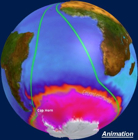
Antarctic Circumpolar Current
)
The Antarctic Circumpolar Current flows around the icy continent
The Antarctic Circumpolar Current is one of the most unusual currents, because it is the only one that is not blocked by a continent. It thus connects all the other oceans, and allows water to flow from one to another.
The Southern Ocean, around Antarctica, is one of the most inaccessible places on Earth. Icebergs, as well as winds and waves that often reach magnitudes rarely found elsewhere, make navigation particularly difficult. As a result, the Antarctic Circumpolar Current is one of the least-studied currents on the planet.
Various Argonautica buoys have already been released into this current, some of them making interesting journeys:
- Julius (2004-2005)
- Carioca (2006-2007), voir aussi A buoy "moves straight ahead"
- In 2000, Euphémos drifted around an eddy in the Antarctic Circumpolar Current (see Currents, buoys and children", Image of the month on the Aviso site in August 2001)
![]() See Beacons locations and maps
See Beacons locations and maps
Malvinas current
)
The Malvinas current
The Malvinas current is a branch of the Antarctic Circumpolar Current, which breaks off after passing through the Drake Passage south of the Americas and flows northward along the contours of the Argentine continental shelf. It is a cold, intense and very turbulent current, especially when it comes into contact with the warm Brazil current.