A buoy "loops around"
Ocean eddies
Observation:
A drifting buoy follows a roughly circular (or elliptical) trajectory, moving in a complete or partial circle (sometimes even making several complete circles) of between 50 km and 300 km in diameter (i.e. 0.5° to 3° in diameter at the equator) over several weeks.Hypothesis:
The buoy is rounding an ocean eddy.
Steps:
Superimpose the maps of the buoy's position on other maps available for the same date.
On the ocean topography maps,
within the buoy's more or less circular path, a "high" (above sea level) or "low" is visible (lower compared to the area's average topography). This high or low indicates the presence of an eddy, around which buoys drift in different directions according to the hemisphere and the type of eddy. In the Northern Hemisphere, water rotates clockwise (anticyclonic) around highs, and counter-clockwise (cyclonic) around lows.
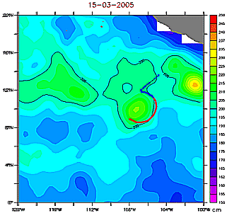 Clipperton's trajectory (2004-2005) in blue and red on 15 March 2005, superimposed on the corresponding dynamic topography map (click on the image to enlarge it). Note that the first part of the trajectory (the straight line) most likely corresponds to the fact that the Argos beacon was activated on the ship, before its release. This buoy can be seen to rotate clockwise around a high (anticyclonic eddy) because it is in the Northern Hemisphere.
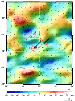 Drifting trajectory of Euphémos, a buoy released in the Antarctic by Marc Thiercelin during the 2000-2001 Vendée Globe race, superimposed on ocean topography variations. The arrows represent geostrophic current velocities (click on the image to enlarge it). The map shows Euphémos (in the Southern Hemisphere) rotating around a low.
Current vector maps
These maps depict current in vector form; direction and length are plotted according to the direction and velocity of the current at the starting point of the arrow. In the case of an eddy, arrows roughly form a circle. In the Northern Hemisphere, currents rotate clockwise around highs, and counter-clockwise around lows. In the Southern Hemisphere, the opposite is true.
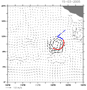 Clipperton's trajectory (2004-2005) in blue and red on 15 March 2005, superimposed on the corresponding geostrophic current map (click on the image to enlarge it). This buoy is located in the Northern Hemisphere, so here it is rotating clockwise around a high (anticyclonic eddy).
This kind of ocean feature can sometimes be seen on maps showing sea surface temperature, salinity and chlorophyll.
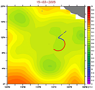 Clipperton's trajectory (2004-2005) in blue and red on 15 March 2005, superimposed on the corresponding salinity map (click on the image to enlarge it). Slightly lower salinity can be seen in the eddy around which the buoy is rotating.
In terms of surface temperature, eddies can be warm (high) or cold (low); however, when water is heated by the Sun, its temperature tends to become homogeneous at the surface, and satellite maps may not necessarily show a temperature difference.
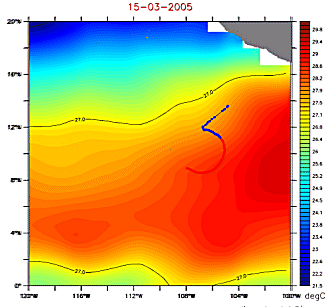 Clipperton's trajectory (2004-2005) in blue and red on 15 March 2005, superimposed on the corresponding surface temperature map (click on the image to enlarge it). At the equator, water is heated by the Sun, so surface temperature maps do not necessarily reveal eddies.
In terms of chlorophyll, cold eddies are generally richer in chlorophyll (there's more phytoplankton in cold waters), while warm eddies are poorer in chlorophyll.
Other examples
- Aviso web site: Image of the Month, August 2001, Currents, buoys and children (Euphémos buoy)
- Aviso web site: Image of the Month, June 2006, Tehuantepec eddies and August 2006, Tehuantepec eddies: a multi-sensor's view on biology (The Clipperton buoy did in fact round one of those "Tehuantepec eddies")
- Aviso web site: Applications, Altimetry and buoys (see bottom animation for buoys circling around eddies)
- Aviso web site: Image of the Month, May 1999, A turbulent sea (several drifting buoy in North-East Atlantic)