Detecting icebergs by satellite
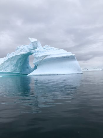 Photo by Ray Laskey on Unsplash |
Icebergs are pieces of glacier that have broken away and subsequently drift across the oceans, sometimes for years. They affect navigation, reduce waves, and are a useful climate indicator. Satellites can detect them in the open ocean.
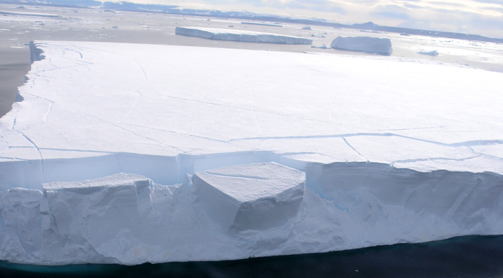 Photo Credit: Courtesy Ted Scambos, NSIDC IceTrek Web site |
An iceberg is a chunk of glacier that has slowly made its way to the ocean and, upon reaching the coast or the end of an ice shelf, has broken off (a process known as "calving") and subsequently floats on its own. Icebergs are therefore made of freshwater ice and not salt water. They do not originate from pack ice (which is sea ice), and they bring a certain quantity of water to the ocean at the time of calving. It is estimated that 50% of all continental ice melting in the ocean occurs through icebergs, which therefore contribute to the rise in sea level. In Antarctica, an entire shelf covering hundreds of square kilometres can sometimes break off. This kind of iceberg (several dozens of metres high above the water and a few hundred metres below the surface) can remain attached at the bottom for a while, but once detached it moves away, primarily following the currents but also the wind. It will break up more and more as it melts, shrinking by an average of 1 m per day (more or less rapidly depending on its size, the ambient temperature of both air and water, etc.). Sometimes it takes several years to disappear completely.
Detecting icebergs from space
Usually, only icebergs at least 100 m long are detected by satellite. However, there are often smaller icebergs close to the big ones because they are pieces that had broken off. Icebergs the size of a few metres are known as "growlers" because as the iceberg melts, air escapes, sometimes resulting in a sound like an animal growling. Growlers are very dangerous for shipping because they are difficult to spot, but large enough to cause significant damage to a boat's hull. Multiple techniques can be used in order to detect icebergs, but none of them allow systematic and continuous monitoring of all icebergs individually.
"Optical" images (using techniques similar to digital photography) clearly show icebergs in broad daylight, and if cloud cover is not too thick. The difficulty with the first condition is that beyond the Arctic Circle, icebergs cannot be tracked for several months each year (since it is permanently dark); the second condition, however, is less problematic. While there are often many clouds over the oceans around the poles, these clouds change rapidly and tend to be thinner; there may even be gaps in cloud cover, meaning that there is a chance of spotting an iceberg over several days of observation. The satellites used for this type of detection are those that systematically acquire imagery of the Earth below them (unlike satellites such as SPOT or Pleiades, which take images intermittently and at scheduled times, with a high or very high resolution). The images taken systematically are not of a very high resolution, which means that only icebergs over 300 m in length can be seen, but areas several hundreds of kilometres wide may be observed.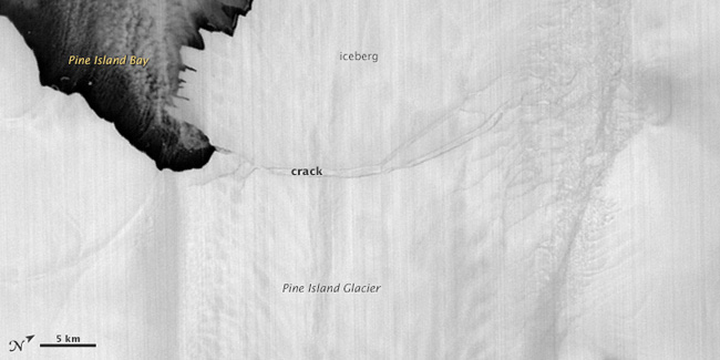
The Pine Island glacier in Antarctica, with an iceberg breaking off on 14 July 2013, as seen by an infrared instrument (the Advanced Spaceborne Thermal Emission and Reflection Radiometer (ASTER) on board NASA's Terra satellite) (source: NASA). Infrared imaging instruments are often present on optical imaging satellites, so they can also be used. Indeed, they are particularly useful during the polar night because infrared instruments detect the radiation emitted as heat from an object or surface, not reflected heat due to solar radiation (the infrared spectrum is also used in night vision goggles). A (frozen) iceberg will be colder than the surrounding (unfrozen) water. However, the difficulties posed by clouds are the same for infrared and optical imaging instruments.- Radars can be used to observe icebergs day and night, regardless of cloud cover.
Imaging radars (synthetic aperture radar, abbreviated SAR) can generally identify 100 m-long icebergs in the images taken. However, these satellites take images as programmed, at particular times and in specific locations, meaning that they would have to be programmed to take images over chosen areas, and thus icebergs would not be seen either by chance or by systematic observation.
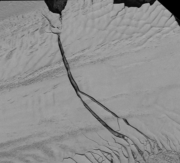
The same Pine Island glacier as above, with an iceberg breaking off, as seen by the TerraSAR-X satellite on 8 July 2011 (source: DLR)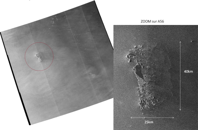
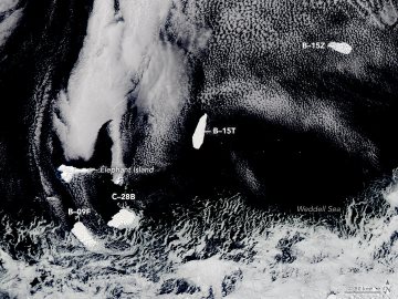
Iceberg A56, detected in the open sea by a synthetic aperture radar on 13 November 2016 (credit: CLS)Radar altimeters only measure directly below the satellite, but on a regular and systematic basis. Sea level is measured based on the time taken by the radar-emitted wave to travel from the satellite to the ocean surface and back; when the radar wave reaches an iceberg, however, part of it returns faster than if it had bounced off the water surface. These satellites cannot detect every iceberg, but can be used to determine trends, estimate total numbers and their movements, identify areas with many icebergs, and so on.

Icebergs (grey dots) detected by the Jason-1 and Jason-2 satellite altimeters between 15 August and 29 November 2012 (in preparation for the Vendée Globe race) (source: CLS)Radar scatterometers are designed to measure near-surface winds over the ocean using the ripples caused by these winds. Specifically, they measure the way the radar wave is reflected off the surface of the water; like synthetic aperture radars, they can therefore detect any objects on the surface that differ from the surrounding environment.
)
)
)
)
Tracking an iceberg
Icebergs lack any reliable form of identification, except in a few rare cases when either a transmitting beacon has been placed on the iceberg (though this does not last many years), or the icebergs are so large that their silhouette is easily recognised from one image to another; most undergo significant change in size and shape as time goes by subsequent to ice breaking off and melting. It is therefore impossible to use computerised shape-recognition techniques to automate their detection, or at least not in the long term. We therefore attempt to reconstruct an iceberg's movements by knowing how they typically move with currents and through a process of deduction based on observations.
) Diagram of typical iceberg movements. Letters A, B, C and D indicate the names given (based on the area of Antarctica from which the icebergs originate) | ) Icebergs detected according to the NATICE database between 1999 and 2010 (Credit: NOAA) |