Infrared radiometers
The infrared radiometers are, by far, the most popular instruments. They are used in both oceanography and meteorology.
What do they measure?
- La sea surface temperature (regarding the ocean)
Principles of measurement
The heated surface emits a "thermal" radiance whose wavelength is in the infrared range (8µm to 14µm) for the temperatures found at the Earth's surface. At the same time, the solar radiance at these wavelengths is weak. Hence, the infrared radiance that we measure when observing the Earth (including its oceans) is directly related to the temperature at the surface. This is a "passive" sensor since it measures radiance without emitting a signal (as opposed to a radar).
Infrared radiance has the advantage of allowing fine resolution measurements (1 kilometre), but the disadvantage, just as for visible radiance, of not being able to go through clouds. When there are clouds, the radiance coming from the surface is blocked and the sensor measures the radiance coming from the top of the clouds. Just as when measuring a chlorophyll data, sea surface temperature calculation techniques, using infrared measurements, must eliminate cloud data which involves making a composite map over several days in order to obtain a complete map without any "gaps".
Measurements obtained in this way provide the temperature of an extremely thin layer at the ocean's surface. We avoid using measurements made during the day since they mainly show direct heat from the Sun reflecting on this film of water.
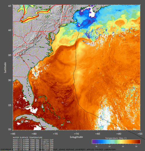
Sea surface temperature in the Gulf Stream region, measured using infrared sensors on NOAA satellites. The white zone in the lower right corresponds to clouds. (Credits: John Hopkins University)
Today's operational instruments
On polar satellites:
- AVHRR on Noaa (Noaa, USA) and Metop (Eumetsat, Europe)
- Modis on Aqua and Terra (Nasa, USA)
- SLSTR on Sentinel-3 A & B (EU/Esa)
- ...
Geostationnary satellites:
- Seviri on MeteoSat (Eumetsat, Europe)
- GOES (Noaa, USA)
- ...