Sea (surface) temperature
)
Satellite surface temperature map for 18/01/2011 in the "Crush" penguin zone. The penguins feed in cold, even very cold, water. (UKMO/EU Copernicus Marine Service - Figure Argonautica)
Sea surface temperature is the temperature of water near the ocean's surface. Knowledge of this parameter is fundamental for several reasons. For oceanographers, meteorologists and climatologists, it is one of the results of the exchange of heat between the ocean and the atmosphere. For marine biologists, it is one of the parameters determining the development and movement of living organisms. For fishermen, its sudden change on a map (thermal front area) usually indicates places where fishing will be productive. For swimmers or divers, it will determine the quality of their holiday, etc.
Specific meteorological phenomena such as El Niño or tropical hurricanes, or, in France the Cévenole rains are direct consequences of ocean temperature variations.
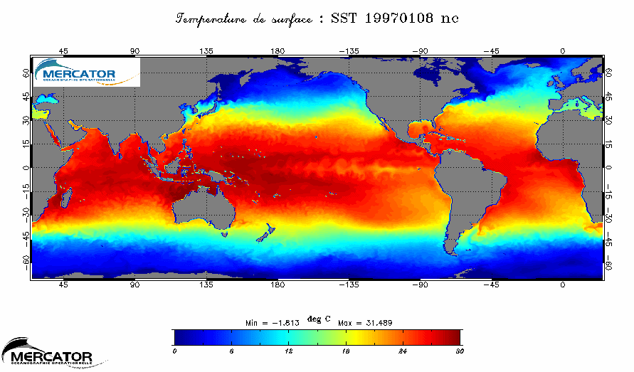 Sea surface temperature during El Niño and La Niña occurrences, in 1997 and 1998, simulated using a model (OPA global ocean model). Warm water moves in latitude according to the seasons, but the temperature variations are found along the same parallel; this is the case in the equatorial Pacific when we go from El Niño (abnormal hot temperatures in the eastern Pacific) to La Niña (abnormal cold temperatures in the eastern Pacific)
(Credits Mercator Océan). Sea surface temperature during El Niño and La Niña occurrences, in 1997 and 1998, simulated using a model (OPA global ocean model). Warm water moves in latitude according to the seasons, but the temperature variations are found along the same parallel; this is the case in the equatorial Pacific when we go from El Niño (abnormal hot temperatures in the eastern Pacific) to La Niña (abnormal cold temperatures in the eastern Pacific)
(Credits Mercator Océan).
|
Orders of magnitude
Sea surface temperature varies from -1.8° C, sea water freezing temperature, to more than 30° in the equatorial latitudes.
Measurement techniques
Satellite measurements
Sea surface temperature is measured using infrared radiometry, which is sensitive to the ocean's thermal radiance and proportional to its temperature. These sensors have the advantage of fine resolution (1 km), but the drawback of being sensitive to cloud cover which corrupts the temperature signal emitted by the ocean.
A second type of sensor is also used: the microwave radiometer which is sensitive to longer wavelengths and is used because the atmosphere does not impede this radiation in any way. Because of the ocean's low energy emission of long wavelengths, the sensors have a coarser resolution than the infrared sensors, of the order of 25 km.
Ocean measurements (in situ)
Ocean measurements are made by oceanographic ships during measurement campaigns, using drifting buoys deployed during scientific missions at sea, as for the Argo network, or anchored buoys such as TAO, PIRATA, etc.
The parameter measured in this case is the temperature a few meters below the surface whereas satellites measure what we call "skin" temperatures at the surface.
Models
The numerical atmospheric or oceanic models also provide sea surface temperatures. The models are validated by comparing the modelled temperature and those measured by different sensors. The above animation shows results from global modelling in the equatorial Pacific for the two years in which El Niño and La Niña occurred.