Microwave radiometers
What do they measure?
Depending on the frequencies used, microwave radiometers measuring the ocean provide us with the following information:
- Sea surface temperature
- Salinity
- Integrated contents of atmospheric water vapour (and associated altimetry correction)
- Integrated contents of liquid water in the clouds
- Atmospheric attenuation
- Rain: precipitation rate
- Sea ice: concentration, drift
Principles of measurement
Radiometers are passive sensors (as opposed to radars, they do not emit radio waves) that measure the intensity of a naturally emitted electromagnetic field for the observed zone in the wavelengths called "microwaves" (between 3 mm (frequency: 100 GHz) and 30 cm (frequency 1 GHz)). Depending on the wavelength, the resolution can vary from a few kilometres (<100 GHz) to several tens of kilometres (<30 GHz).
Infrared sensors are also radiometers, but they measure shorter wavelengths (see: infrared radiometers).
Technically speaking, radiometers produce a voltage.
By using this raw measurement, a brightness temperature (intensity of an emitted electromagnetic field) is returned by the instrument thanks to its characteristics (radiation pattern of the antenna, variation in temperature of the electronic components, etc.).
Geophysical data (temperature and salinity) are determined from the brightness temperature (Tb) by using a priori knowledge of the body's dielectric constant that emits and the roughness of the emitting body's surface.
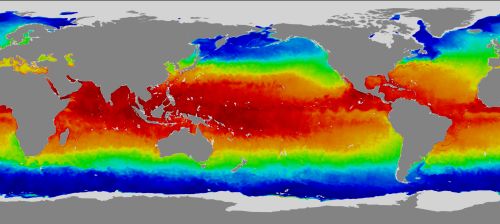
Surface temperature map provided by the AMSR-E sensor (Credits NASA)
Today's operational instruments
- SSM/I on the DMSP series (Nasa, USA)
- TMI on TRMM (Nasa, USA)
- AMSR-E on Aqua (Nasa, USA and Jaxa, Japon)
- AMR on Jason-2 and 3 (Cnes, France, Eumetsat, Europe, Noaa and Nasa, USA) (but those latter two are essentially used to correct measurements from the altimeters also onboard the same satellites from atmospheric water effects)
- SLSTR on Sentinel-3 A & B (EU/Esa)