The Argo floats network
What do they measure?
- La temperature
- La salinity
- Les deep currents
Principles of measurement
The objective of the Argo programme, launched in 2000 by Unesco's Oceanography Commission and the World Meteorological Organization, is to provide in situ temperature and salinity measurements in real-time according to depth (or temperature and salinity "profiles") throughout the ocean. The name Argo was chosen to illustrate the complementarity with the Jason altimetry satellites (in Greek mythology, Argo is the name of the ship on which Jason embarked with the Argonauts in search of the Golden Fleece). This worldwide observation network is an indispensable complement to satellite observations for operational ocean forecasting systems.
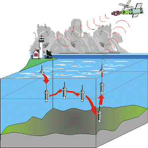
The Argo float network today includes more than 3000 floats capable of diving to depths of 2000 meters, distributed over grids 300 km by 300 km. The float resurfaces every ten days and measures ocean temperatures and salinity along its ascension path. Once on the surface, it transmits collected data to the satellites (Argos and Iridium) before diving again to pre-programmed depths. The data are distributed free-of-charge in real-time and with no restrictions on their use. Today, in addition to the European Union, some thirty countries collaborate in the Argo network. The French component in Argo is the Coriolis project; it includes the instrumentation (development of the Provor and Arvor float models), the deployment of the instruments and the processing of data (Coriolis, the French processing centre, in one of the two Argo global processing centres).
Today's operational floats
)
Active Argo float map (Credit: Argo project)