Buoys and turtles exploring the Western Mediterranean Sea ways
Observation:
Argonautica tracked several buoys and some turtles in the Mediterranean Western basin, especially around the Balearic Islands, and/or along the Spanish coasts. Rather than study a single track, we will analyze the region as seen by the different observations we have there.
- Experimental buoys built by the Lycée Monteil (Rodez, France) – Médée, Téthys, Scylla & Méduse, and their accompanying drifting buoys Phébus, and Pégase2019, aimed at studying the Liguro-Provençal-Catalan current
- Coris & Coris-2 drifting buoys, Childoceans,
- Loggerhead turtles (Caretta caretta) Anna-Antimo, Gloria, Jess, Jo-Baléares, Ninja-Baléares, Thunderbird and Vita (equipped on Balearic Islands and tracked by SOCIB); Antioche also, from La Rochelle aquarium, which went into the Mediterranean Sea from the Atlantic Ocean.
- Additionally to those, one Ocean Drifter Iridium (ODI) buoy, launched in the northern part of Mallorca Island in May 2014 by SOCIB will also be analyzed.
Along the coasts: Pégase2019 and the first legs of Coris & Coris-2 travel
Pégase2019 was deployed from Banyuls, a French harbor hosting an oceanographic research center, very near the French-Spanish border, on the Mediterranean Sea. Coris and Coris-2, on their side, were deployed on the 2nd October 2018 and on the 20th of October 2020, respectively, off the coasts of Nice (France)
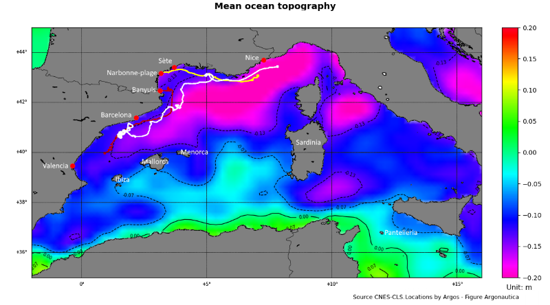
Map of the Western Mediterranean Sea showing the first part of the trajectory of the Coris (white), Pégase2019 (red) and Coris-2 (yellow) buoys, overlaid on the mean ocean topography (corresponding to the mean currents). All three buoys, at this stage, are following the current a bit off the coast.
The path along the coasts from Nice to Catalunya is in agreement with the permanent path of the surface current there, called the Liguro-Provençal or Liguro-Provençal-Catalan current (see the Mediterranean currents). This current, not very wide (35 km), is running along the coast at a constant depth of about 250 m at a maximum speed of 0.3 m/s (about 1.10 km/h). In the southern part, it weakens and it detaches from the slope, feeding on the one side the Balearic current.
The first part of Coris travel was also along the coast, drifting with this currents, but the buoy went over the continental shelf early October 2018 (winds were East a bit later) and it ended on a beach near Narbonne, France (once re-released off Sète, France, it went straight South).
Coris-2 followed the Liguro-Provençal-Catalan current, too, joining the Balearic current in the north of Ibiza Island towards the east (see the map of the Mediterranean currents paying attention to the recirculation path).
Its path through the Mallorca-Menorca channel is very rare, but also similar to the one followed by an ODI buoy, launched in the northern part of Mallorca Island in May 2014 by SOCIB.
Both Pégase2019 and Coris-2 then had a very different destiny.
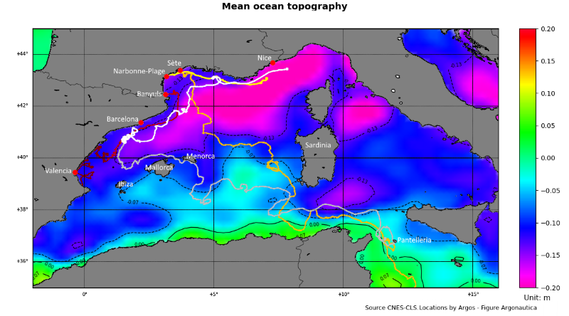
Map of the Western Mediterranean Sea showing the full path of all three buoys (white-grey for Coris-2, yellows for Coris, reds for Pégase2019)
Pégase2019 to the coast (again; and again)
After that, Pégase 2019 went to the coast in Valencia gulf, three times in a row, redeployed twice thanks to SASEMAR, the Spanish Maritime Safety and Rescue Society, during their routine training exercises.
This may be due to the moist winds blowing over the sea toward the coast, which might have pushed Pégase2019 towards the mainland over and over again three times. Once on the continental shelf (the part of the sea continuing the continent, with less depth and a steep underwater cliff marking the break from it to the "open" sea), the currents and winds kept driving it to the shore.
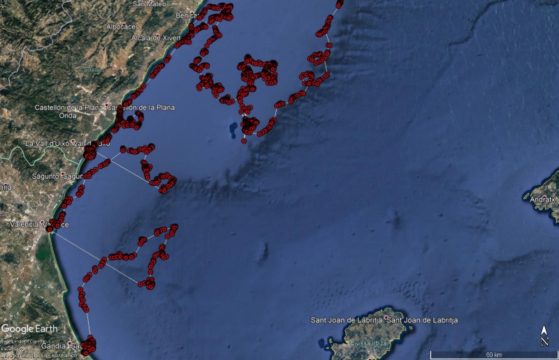
Zooming map of the Spain's eastern coast using Google Earth on the path of Pégase2019 from end of May 2019 to its final landing mid-August (part in dark red in the previous map), with the two re-deployments (straight lines from shore to open sea). On the two occasions it went back -- more or less rapidly -- to the coast.
Coris-2 around and across the Balearic Islands
Coris-2 did not go to shore. It went South off the shelf. Then it followed Eastwards the coast of Mallorca (seems to fit the geostrophic current there). After that, unusually it went in between Mallorca and Menorca -- when the general scheme would be more North of Menorca. It matches the currents computed by SOCIB over this precise region, though (see animation below).
Animation showing the Coris-2 surface drifting buoy trajectory over WMOP model currents and temperature mid-Nov.-mid dec (Credit SOCIB)
However, although such a path is not common it was also observed earlier when an ODi buoy launched in the northern part of Mallorca Island did a similar trajectory in May 2014, as it can be seen on the map below.
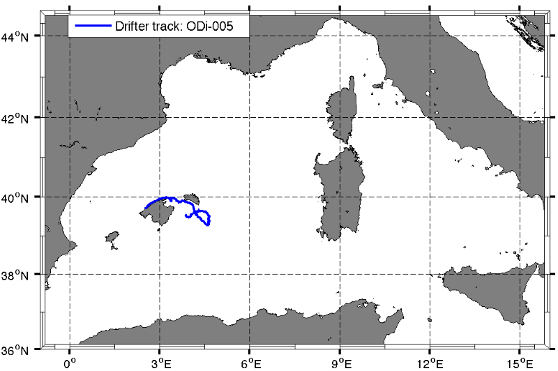
Map of the Western Mediterranean Seashowing the trajectory of the ODi buoy, launched in May 2014 by SOCIB in the northern part of Mallorca island (Credit SOCIB)
Coris-2 then crossed the sea between Balearic Islands and Sardinia at a Southern latitude, without much meandering.
Phébus and Coris: Southwards and then looping around the Sardinia Sea
When looking at Coris in December (after re-deployment) and at Phébus, their tracks are across the main coastal current and the North Balearic Front (see the Mediterranean currents). However, in both cases, winds could explain their move offshore. Coris from redeployment and Phébus: the latter stayed turning around in the Sardinia Sea (much like some of the turtles, see Jess, Jo-Baléares and Vita), while Coris "escaped" after only one loop in the process.
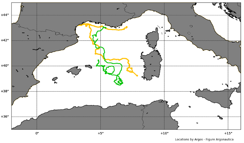
Map of the Western Mediterranean Sea showing the trajectories of Coris (up to Jan. 8, 2019) in yellow and Phébus (complete track, May-August 2015) in green. The large loops often match a temporary underlying "hill" or "trough" in the ocean topography (i.e., an ocean eddy).
Coris and Coris-2: looping near Pantelleria Island
Both Coris and Coris-2 began going out of the Western Mediterranean basin through the strait of Sicily (i.e. an almost 150 km wide channel between Sicily and Tunisia). Coris did a little loop, counter-clockwise, near the Island of Pantelleria (which lies in the middle of the strait), Coris-2 did, too, slightly North of it. Oceanographers recorded a seasonal eddy there, present in Winter and Spring, but they are not all in agreement on its rotation direction.
Coris-2 stopped emitting there. Coris ended up in Tripoli's harbor (literally)... which seems to fit the general Mediterranean circulation (see the map of the Mediterranean currents)
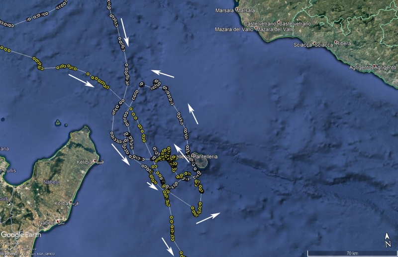
Zooming map of the Sicily Strait (between Sicily and Tunisia) showing the trajectories of Coris (yellow) and Coris2 (white) near the island of Pantelleria. Both did a counter-clockwise loop in this area in agreement with the sense of rotation of the Pantelleria eddy, as it was first identified in 2011
Inertial oscillations
Pégase2019 and Coris-2 show "corkscrew-shaped" path (ie. the buoys are coming back home like a Foucault pendulum, back and forth see e.g., Foucault pendulum facts for kids) at some point in their trajectory, at a time when the wind has dropped in the area and there were even fewer currents: this might be due to what is called "inertia oscillations", i.e. they continued on their move. In this case, the fact they are doing small loops is linked to the Earth rotation -- which never stops. Phébus track also shows loops like this, each lasting around 18-19 hours. See the case study La Fille de l'Atlantique driven by the Coriolis force, even if measuring the time between two loops is harder in those cases than in the tell-tale example of La Fille de L'Atlantique, or, more recently, of Le Pingouin, probably since there are some currents around, and winds from time to time.
Surface currents in the Mediterranean Sea

Map showing the surface currents in the Western Mediterranean Sea. Adapted from: http://medclic.es/en/resources/detail/67 (teaching unit published by the Balearic Islands Coastal Observing and Forecasting System (SOCIB). The Liguro-Provençal (turquoise arrows) current is the one followed by Coris, Coris-2 and Pégase2019 in the first leg of their trajectory. The current above Mallorca matches the 2nd leg of Coris-2 travel. In between Balearic Islands and Sardinia there are no permanent currents, more eddies changing all the time. The currents out of the Western basin are those followed by both Coris, with the landing in Libya more or less coherent with one of the arrows. The seasonal eddy near Pantelleria is not on this map. (Credit SOCIB)
The Mediterranean Sea is a semi-enclosed basin connected to the second-largest of the world's oceans, the Atlantic Ocean, through the Strait of Gibraltar. For this reason, the Mediterranean Sea is considered like an ocean in miniature, where the currents are being driven by different phenomena and forcings of diverse spatio-temporal scales: from the large-scale thermohaline circulation which drives currents due to water density differences around the globe until small-scale atmospheric forcings as the land-sea breeze on the coastal areas. This small sea is one of the most oligotrophic (it means, with low phytoplankton biomass and low primary production) areas in the world, decreasing eastwards (check out the maps showing the Chlorophyll-a concentration). Nevertheless, higher levels of nutrients and thus, phytoplankton abundance, are found in coastal nearshore waters and related to finer structures (e.g. on the edges of the clockwise & warm-core eddies and in the cold-core of the counter-clockwise eddies, along the fronts), specially in the Western sub-basin. Some of these eddies are quasi-permanent features (ie. they can be observed almost always at the same place) and oceanographers usually assign a name to them, while others eddies are more variable (i.e. their generation would ultimately depend on the winds, season, etc.)
Now, pretend you are a drop of water entering through the Strait of Gibraltar immersed in the Atlantic Jet flowing eastwards into the Alboran Sea at the surface. At this point, your temperature will be 17ºC and your salinity will be 36.2, on average. Once you are in the Mediterranean, and after a few turns around the Western and Eastern Alboran eddies, you will follow a counter-clockwise path while exploring the Mediterranean coasts (from Algeria, Tunisia, Libya, Egypt, Israel, Lebanon, Syria, Turkey, Greece Albania, Montenegro, Bosnia, Croatia, Slovenia, Italy, France and Spain). Along your route you will become saltier and warmer (38.9 and > 22 ºC in the Levantine Basin) due to intensive heating and evaporation of the surface water and you will encounter less nutrients and less phytoplankton in the eastern regions. Furthermore, you will have a lot of fun turning around the common energetic eddies (with spatial scales of 10-100 km; lasting for days or even months) bounded by current meanders and bifurcating jets. Just after 80 or 100 years (which is the time for water renewal in the Mediterranean), your journey will finish at your initial point, exiting from the Mediterranean through the Strait of Gibraltar, but this time at deeper levels, as an older, colder, saltier and hence, denser drop of water.
More information on Mediterranean Sea current in video (Credit SOCIB)
More information:
- Teaching Units: MedClic http://medclic.es/en/el-mar-y-sus-costas/ & module on Currents http://medclic.es/en/resources/detail/67. You can find much more information in MEDCLIC
- Argonautica The main currents over the course of the around-the-world alone Vendée Globe sail race
- Video of the WMOP ocean model and the Coris-2 trajectory around the Mallorca-Menorca Channel (around the Balearic Islands): https://youtu.be/S0MRPDF7JZ8
- Video about the Mediterranean Sea: English version, Spanish version
 | SOCIB Teaching units, figures and video are distributed under an Attribution-NonCommercial-ShareAlike (CC BY-NC-SA) license. This license lets others remix, tweak, and build upon our work non-commercially, as long as they credit and license their new creations under identical terms. The materials can be reproduced and re-used, with attribution/credit to us in print and on your web platform: Balearic Islands Coastal Observing and Forecasting System (SOCIB). |

