Altimeters
What do they measure?
- Sea surface height and other water heights (lakes, rivers)
- The strength of wind speed at the surface of the ocean (but not its direction)
- The height of the waves
- Les Sea ice (to a certain extent)
Principles of measurement
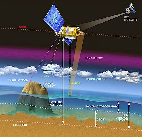
Principle of altimetry measurement (Credits CNES/ D. Ducros)
Altimeters are radars, in other words, "active" instruments (they send a signal rather than merely receiving a signal). Altimeters send a radio wave straight towards the ground (also called "at nadir") and measure the received return signal. They generally use frequencies around 13.6 GHz, but also 5.3 GHz or 35 GHz. These frequencies cross through the atmosphere easily and are not very perturbed by the atmosphere's water vapour (i.e. they enable to see through clouds).
Among the information measured, the most important is the time required for the wave to make the round trip which lets us determine the distance between the satellite and the surface (the radio wave's speed is the speed of light). This measurement, coupled with the precise position of the satellite, will provide the "water surface height", in other words, the height of water in relation to a reference (either mathematical such as the reference ellipsoid, or more physics-related like geoid or mean sea surface height over several years). Thus, we obtain the total height of the water, the deviation from the mean height, or (over oceans) a height corresponding to currents and everything that "moves" in the ocean.
Moreover, the shape of the return signal received by the satellite and its strength allow us to determine respectively the height of the waves (the shape, since the radar wave reflects first on the crest of the waves, and finally on the trough) and wind speed (since the reflection is oriented in all directions due to surface roughness, the strengh is less powerfull when there's wind). Sea ice can also be partially spotted using today's altimeters (even more efficiently when their measurements are combined with radiometer measurements); the Cryosat (ESA) satellite altimeter is dedicated to this type of measurement.
Instruments currently working
- Siral on Cryosat-2 (Esa)
- AltiKa on Saral (Cnes/Isro)
- Poseidon-3B on Jason-3 (Cnes/Nasa/Noaa/Eumetsat)
- Sral on Sentinel-3A & B (EU/Esa)
- HY-2B & C (CNSA)
- Poseidon-4 on Sentinel-6 Michael Freilich (Esa/Eumetsat/EU/Nasa/Noaa)