Sea surface height
The ocean's surface is not flat. There are hollows and bumps caused by different physical phenomena: gravity fields, currents, temperature & salinity... Moreover, we know little about the relief of the sea floor. As a result, instead of using the depth, we use the "sea surface height", the height of the water compared to a reference surface. From this sea surface height, especially its variations, we determine the oceanic circulation (currents and eddies rotate around the hollows and bumps), the seasonal and inter-annual variations; and over even longer periods, the variations of the ocean's mean level.

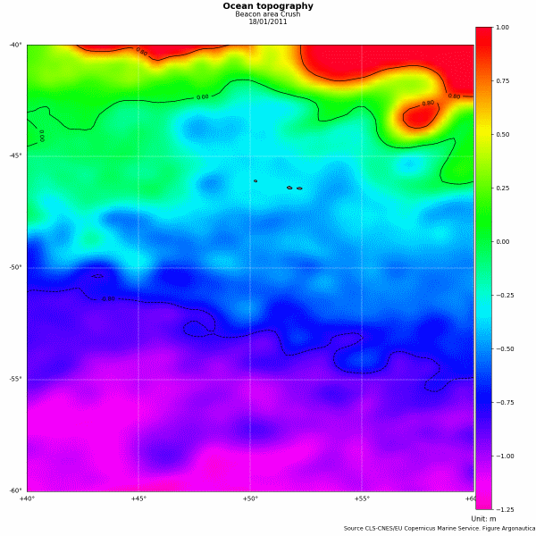
Ocean topography map ("dynamic topography") for 18/01/2011 for the "Crush" penguin zone. The zones in red correspond to places where the sea surface is higher. It decreases towards mauve (CLS-CNES/EU Copernicus Marine Service - Figure Argonautica)
Orders of magnitude
Sea surface height can only be measured in relation to a reference. Sea surface heights are determined by means of a reference ellipsoid (simplified shape of the Earth), by using a geoid (surface due to the Earth's field of gravity), or by using an average surface calculated over several years (in this case, we only see the variations). The respective orders of magnitude are:
- sea surface height in relation to the reference ellipsoid: +/-100 m.
- sea surface height in relation to the geoid (or dynamic topography): from -1 to +3 m (used by Argonautica). This height includes the variations (namely eddies, cf Une bouée fait "un rond dans l'eau") such as the height due to the major currents (Gulf Stream or the Antarctic Circumpolar Current see above. Cf Les grands courants au fil du Vendée Globe or Une bouée "file droit devant").
- " Sea surface height in relation to a mean surface (often referred to as sea level anomalies or sea surface height anomalies): from +/-0.15 m in calm zones to +/-1 m in turbulent zones (NB: this sea surface height only includes the variations: eddies, current variations, movements of water masses, etc.)
Measurement techniques
Satellite measurements
Models
The models simulate the sea surface height and generally produce the "dynamic topography" (in relation to the geoid).

