Sea ice
The terrestrial poles and their ice floes (frozen sea water) are in the front lines. It has been observed that the ice floes at the North Pole have been continuously diminishing since 1979, while those of Antarctica have remained stable, and have even increased slightly. The climatic, economic and geopolitical stakes are high and, today, polar sea ice is an essential parameter to be measured, monitored and forecast.
The two poles are quite different: the North Pole is an ocean surrounded by land whereas the South Pole is a vast continent surrounded by the ocean. The South Pole sea ice surrounding the Antarctic continent is open to the ocean and, as a result, is free of its movements. Because of this, it is almost entirely renewed each year, with the exception of some rare places such as the Ross or the Weddel Seas. Because of this, the ice floe at the South Pole is never very thick (1 metre on average).
At the North Pole, the ocean dynamics are very different: while the transpolar current, flowing from Siberia to Greenland (Straight of Fram), allows the ice to evacuate southwards and melt, the closed Arctic basin traps it. In some places such as the Canadian Arctic Archipelago or the Beaufort Gyre, ice can remain blocked and accumulate for several years without melting. In this case, we talk about multi-annual ice of the second, third,..., seventh, as much as ninth year. Its average thickness is 3 metres.
Orders of magnitude
Sea ice is characterised by means of several parameters: its concentration or compactness (expressed in %), used to measure the percentage of vacant surface (from 0 to 100%), the edge of the ice pack (the pack's limit is defined as the frontier beyond which 85% of the ocean's surface is frozen), its type (first year, multi-annual), the speed of drift on the ocean, its thickness, and the date of its breaking up.
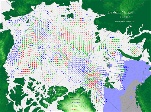
Speeds of ice drift at the North Pole (Credits Cersat/Ifremer)
Measurement techniques
Satellite measurements
Divers types de capteurs satellitaires permettent de mesurer la glace de mer : Several types of satellite sensors allow measurement of sea ice:
- Microwave radiometers (concentration, or the percentage of the ocean surface that is frozen, and drift, the movement of the ice)
- Microwave scatterometers (extent of the frozen surface, border between water and ice, type of ice)
- Infrared sensors, and optical sensors (extent of frozen surfaces)
- SAR (Synthetic Aperture Radar) sensors
- Altimeters (extent, iceberg detection), particularly the Cryosat mission (also measures the thickness of ice and the border between water and ice).
Models
The processing of sea ice in ocean models is a reality today. The ice models are "coupled" with ocean models: the ocean model provides the ice model with data on the state of the sea (temperature, salinity and current) which are required to calculate the evolution of the ice parameters that are processed (thickness, compactness, and speed of the ice). In turn, it modifies the ocean parameters: it "makes" or "melts" the ice, it "cools" or "heats", "un-salts" or "over-salts" the sea water. These new characteristics can then be inserted into the ocean model.
Several ice models are already operational:
- The French Mercator global model that takes both Poles into account
- The Norwegian NERSC model